 |
||
08/22/08 |
|
|
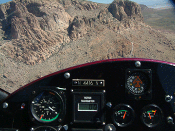
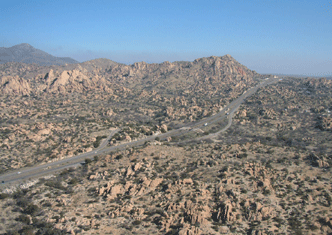
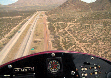
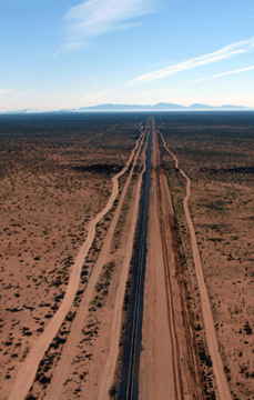
Arizona- New Mexico- Texas Friday, Feb 25, 2005 FFZ- AVQ, Mesa Arizona to Marana, Arizona The day dawns clear and blue with a few puffy cumulus clouds dotting the valley. The back to back storms that have caused massive flooding in California and Las Vegas were predicted to hit here but drier air has moved in and flying looks good. Lots of last minute details to take care of and it's 10:30am before we are at the airport. My gyro CFI Scott Tinnesand comes over from his nearby hangar where he is on call as an EMS rescue helicopter pilot. He helps to fuel and pre-flight as well as get Dee rigged up with the motorhome towing our Jeep Cherokee. I've got a few minor butterflies but in truth am more concerned how Dee will do on her first solo driving the motorhome. I get lots of good wishes from Mark, Julie, Shane and Harold at Air West. We take a few pictures in front of the hangar then taxi over for a last minute photo of Scott and I in front of the A-star life saving helicopter he flies. In a few minutes I taxi off for departure from Runway 4R at Mesa, Arizona's Falcon field. Our destination for today is only a short hop of about 70 nautical miles for me but 110 road miles for Dee. I spin up my rotor blades at the hold short line with a close eye on my rotor tach which I had adjusted after my last flight. It had started reading way low in flight so I adjusted it and now it's not working at all. Nothing critical as I know my system well enough to guess it pretty close. I decide to have a long taxi to make sure it is up to speed before I add full throttle and this works fine and in seconds I'm airborne and on my way- Whoope -- let the adventure begin. A few miles later I'm out of everyone's airspace but still on the tower frequency when I hear them tell someone that he is cleared to land and a B-17 is on approach behind him. Whoa- that would get your attention. The air is smooth and I'm enjoying my flight south at 1,000 feet AGL over mixed cactus and farmlands. I play around with trim settings but they are adjusted as loose as they can be and the machine still wants to climb unless I hold lots of forward stick. I think tomorrow I'll try some more ballast weight on the cockpit floor. As I near Coolidge airport there are about 4 aircraft doing touch and gos as well as 3 or 4 inbound and outbound. If I were transitioning in a fixed wing I would just get well above them and make a call about transitioning their space but now I'm just about at pattern altitude and I realize I am a continuous hazard to everybody. Even if I climb up a bit I'll be where the inbound and outbound traffic are and at only 50 knots it'll take me a long time to be out of the danger area. I decide to do what's most fun in a gyro- I hit the deck and announce "Cooledge traffic this is gyroplane 4416 November. I'm down in the weeds at 200' AGL transitioning North to South 2 miles west of the field." Now this is really fun and with smooth farm fields below me I'm confident I could land anywhere if need be. A bit farther south I pick-up Interstate 10 and look below for Dee. I make a quick call on our agreed air to ground frequency but I know she is busy piloting the motorhome so I tell her not to answer even if she is listening. I hope she is having as much fun as I am. My sectional shows that I have several towers ahead so I stay at 2500 feet to be above them all as I pass Pinal airport. By then I'm picking up the AWOS giving weather for my destination at Marana Regional Airport. It is an uncontrolled airport meaning they have no tower, but it is quite busy as its just north of Tucson Arizona. Traffic on frequency includes a King Air, a long Ezy and several Cessnas plus a load of skydivers. The jump plane pilot does this run a dozen times a day and is clearly bored with the routine of it. He knows exactly how and what he is going to do to get back on the ground as fast as possible for his next load. He makes his call about unloading the jumpers and his follow up position announcement so fast I don't catch a word. I consider mentioning to him that the purpose of his announcement is so everyone else knows where he is but I hold my tongue. I can see where the drop zone is so I know the skydivers are on the other side of the field. Three of us are approaching downwind at the same time and after several calls we sort out who is where. I'm in front and close in but tell the Cessna to land first as he is so much faster. A Russian Sukhoi is screaming in behind me so I promise him I'll land right at the taxiway turn-off and clear the runway fast. I turn final over the numbers and float on down the runway touching down about 20 feet in front of the taxiway and then watch as the Sukhoi comes burning in a minute later. WOW! Our first hop is over. I park at the transient area and am answering questions about my machine even before I can stop the engine. After puttering around the machine for a bit I pack-up my daypack and head for the FBO. Just as I round the corner of a hangar I see Dee pulling in to the airport parking lot in our motorhome-- my heart soars. She hops out with a HUGE grin on her face and I soon match it as I wave wildly. We're both like little kids - proud of our accomplishments and excited that this crazy idea of traveling the Highways and Flyways like this may actually work. We have lunch at the Sky Rider coffee shop and spend the afternoon puttering around the gyro trying to fix the rotor tach to no avail. The aircraft here are a wonderful mix and a semi-truck on the ramp indicates it is the support vehicle for the Red Baron Pizza team of 4 Stearman bi-planes. I don't see the Stearmans but there is an aerobatics practice box nearby and we watch unidentifiable aircraft give us our own private airshow.
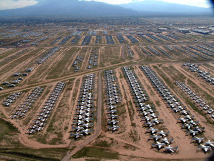
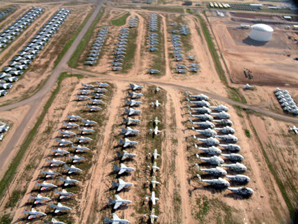
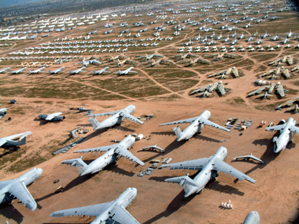
Saturday February 26, 2005 AVQ-E95, Marana to Benson, Arizona Up early and Dee walks out to aircraft with me to watch as I preflight. She notices a broken battery cap and kindly makes the walk back across the ramp to the motorhome for a spare which fortunately we have. I'm still without a working rotor tach despite spending an hour troubleshooting it yesterday afternoon. Everything else looks good though so I crank her up, taxi out for runway 12 and am soon climbing into the blue Arizona sky. Tucson International airport is just ahead and I need to get on the radio. "Tucson Approach- experimental gyroplane 4416 November requesting clearance through your airspace. I'd like to fly over Davis Monthan Air Force Base at 3,200 feet." The controller says he is unfamiliar with the term gyroplane. I explain that I'm flying a kitbuilt aircraft that is a sort of cross between an airplane and a helicopter. He responds with an "oh," then bites off his next question and gets back to business giving me a squawk code and asking me to ident. I punch the code he has given me into my transponder so now he knows which blip on his radar screen is me. Then I push the ident button which causes my blip on his screen to light up so he can quickly see where I am. A moment later he responds that he has me radar contact 18 miles West and I'm free to fly on my way. I navigate for the Air Force base just north of Tucson international. It is a Saturday and all is quiet here but I see F-16's and helicopters lining the ramp ready to fly. Just past the runway I see row upon row of decommissioned aircraft. The mothball fleet at Davis Monthan is HUGE- as far as the eye can see are every type of airplane imaginable from B-52 bombers with their wings off to smaller fighters to aerial tankers. I've never seen so many planes- hundreds and hundreds of them parked in long lines that extend to the horizon. I take as many pictures as I can in amazement, then the rows of planes stop and I'm over houses and tennis courts. But a moment later there's another thousand planes in neat lines in the desert. They remind me of the endless white markers at Arlington National Cemetery and seeing so many aircraft like this is both wonderful and sad at the same time. After Tucson the terrain gets more interesting and I enjoy flying over open desert. I've climbed up to 4,500 feet and the gyro is performing great. Moving 25 lbs of ballast from the passenger seat to the floor in front of the passenger seat has helped trim the aircraft making it easier to fly. I call ahead to Benson Airport and am the only plane landing there so I crank a tight turn right over the airport to see the windsock and then touchdown exactly where the runway meets the taxiway. I could never land a fixed wing plane with this precision but in a gyro even a novice pilot like me can manage it easily. Before I can taxi the 100' to a tie-down spot all the locals are out to see my unique aircraft. After answering questions for 20 minutes I tie the gyro down, clean the windshield, do a post-flight check then pull on the protective covers Dee has made for me. I expect Dee to arrive in the motorhome any minute now but instead I get a phone call from her that my directions to the airport are all wrong. My instructions have taken her down a dead end dirt road. With the Jeep in tow behind the motorhome backing up is not an option. She is forced to unhook the jeep with all its tow bars, wires, and lights, then back the Jeep up and drive it down the road to turn around. Next she jockeys the motorhome back and forth on the dirt road until she is facing back the way she came, then she returns to the Jeep drives it up behind the motorhome and does the hookup with tow bar, safety cable, runaway brake cable, light cable and auxiliary braking system for the Jeep. It's a complex process and I fear I'll hear her wrath when she arrives. Instead she drives up with a smile on her face proud of herself that she dealt with everything so well. She tells me at least the scenery was pleasant with the alpacas and nubian sheep grazing on the farm nearby, though the barking great dane and terrier were not so nice. Her desert experience was complete when she had a roadrunner sprint across her path on the paved road to the airport. We spend a few minutes with John and Nancy, the delightful couple that live on and run the airport here. I ask Nancy if the story I've heard is true and she confirms it is. It seems the rescue helicopters stop frequently in Benson for fuel and it was usual for her to run out in her satin pajamas in the middle of the night to hot fuel the A-Stars while the pilots kept the blades spinning and engines running. Now that's good service! From here we depart in the motorhome to Bisbee, Arizona for a few days so Dee can attend a yoga workshop before we continue on our way East.
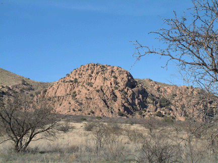
March 1, 2005 E95-LSB-DMN Benson, Arizona to Deming, New Mexico After two days exploring Bisbee and Benson and visiting the fantastic Amerindian museum we're back into traveling mode. I'm off Benson at 9:30 am, a compromise between an early start and waiting for it to warm up so I'm not so cold. Flying with the doors off is more scenic and the gyro handles better in cross-wind landings. My first leg to Lordsburg is 1.8 hours and I mostly follow Interstate 10 to keep to lower elevations. The scenery is fantastic with huge rock boulders surrounding the interstate in the first section through the Dragoon mountains. I'm flying at about 5,000 feet which puts me 1,000 feet over the terrain. I can see 50 miles easily and don't encounter any other traffic as I swoop down into Lordsburg for fuel. The windsock agrees with my GPS and shows I've got a 10 knot tailwind. The FBO (Fixed Base Operator) who runs the airport is glad to see me as the 12 gallons of gas I buy is his first sale of the day. I get the usual questions about my gyro and am happy to supply answers. After a short warm up I'm off again- the weather is clear but my destination at Deming, New Mexico is predicting strong winds for this afternoon so the earlier I arrive there the better. I decide its time to see how well my gyro will do when I need to climb high over the Rockies on my trip back West. Taking off from Lordsburg at 4,278 feet I climb out well. The rate of climb slows down as I get over 5,500 feet but I make it up to 7,000 feet OK and decide that is enough for today. With the temperature at 17 degrees Celsius that is the equivalent altitude of 8,100'. Reducing power I lower the nose and drop all the way down until I'm only 100' off the dry desert floor and I watch my shadow race across the landscape. By now the tailwind has really picked up and my GPS shows the highest speed I've yet seen at 76 knots which is equal to 87 miles per hour. As I come in for landing at Deming the wind is being reported at 16 gusting to 22 knots. That's a lot for my little gyro but fortunately it is only 30 degrees off of the runway heading so I won't have to fight a cross wind. I keep lots of power on and the strong wind lets me do a near vertical landing with no ground roll. I have to throttle back up just to taxi off the runway. What a fantastic day- the trip is turning out to be as much fun as I had hoped.
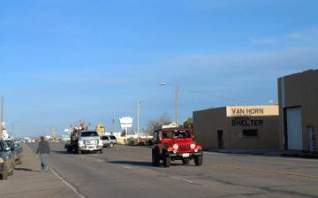
March 2, 2005 DMN-PEQ-VHN Deming, New Mexico to Van Horn, Texas I take off from Deming in calm winds and immediately turn on course for El Paso, Texas. Dee's route on Interstate 10 dog legs north to Las Cruces but I fly the rhumb line towards El Paso. Each time the terrain climbs a bit I feel more wind gusts- nothing serious but enough to get my attention. All is going well but as the day moves on the winds pick up a bit. I'm glad for the tailwind but up ahead is a series of mountains and I'm concerned about how rough it might get where the wind hits the mountains. As I ponder this I notice something I missed before when looking at my map- the road I'm following goes through a narrow pass between two mountains. It could get very bumpy there and I'm angry with myself for not noticing this important detail last night when I did my planning. If I fly North to make an end run around the mountains I'll be going out of my way quite a few miles. I decide to bail out and go around but no sooner have I altered my course than I get concerned about having enough fuel for the detour. A moment later I turn back south. But as I continue to feel the gusts and look towards the narrow pass I change my mind again. I spend a minute or two punching buttons on my GPS to calculate the distances. Indecision is hell but I finally decide to go the safer route North of the mountains. Once the decision is made I relax again and enjoy the flight. After rounding the mountains I call the approach controller for El Paso International Airport. I do not want to detour around their airspace so I ask for a clearance and am given a discrete transponder squawk code and told to proceed on my way. A few minutes later though the controller asks me to fly a heading of 090 to stay clear of where she has 727's in-bound. She takes me a bit out of my way then turns me farther south and eventually lets me continue on a direct line for my fuel stop at Fabens, Texas. My landing here is uneventful and I'm the only aircraft on the ramp. The Hispanic couple that run the airport are very kind and full of the usual questions about my trip and my gyroplane. The Mexican border is only a few miles away and so I ask them about flying along the Rio Grande river separating the U.S. from Mexico but they are not pilots and have no answers. I decide I had better file a flight plan- at least that way if Customs or the Border Patrol come down on me I won't look like I've tried to hide something. The flight plan briefer says he guesses it's OK to fly along the river as long as I don't actually fly over Mexican soil. After taking off I roll the gyro into a tight turn and fly past the waving Hispanic couple from the airport. The woman calls on the radio and wishes me a safe journey. I follow Interstate 10 for a few miles then decide it's time to see Mexico. My GPS shows the border just a few miles away so off I go. I remember all the John Wayne westerns where they swim their horses across the river and that's the scene I'm looking for. Nothing in sight but the map shows the border RIGHT HERE- shit it dawns on me that this tiny muddy creek I'm crossing IS the Rio Grande. I turn the gyro on its side in a steep turn and get back to the US bank. Well maybe I did fly over the river but I can honestly say I did not fly over Mexican soil. Anyway this ditch barely has any water in it and there is certainly nothing Grande about it. Oh well another myth shattered. In a few minutes I'm back over the interstate and I follow it looking for Dee down below me. The terrain is flat so I drop down to about 100' off the ground and fly beside the road waving to kids in the passing cars. I'm having a great time and the gyro is flying beautifully. I go for minutes at a time barely touching the controls. About 25 miles outside my destination the gusty afternoon winds pick-up. My Westerly tailwind has turned to a Northerly crosswind and the gyro yaws from side to side as I'm hit by fierce gusts. I call Van Horn but no one answers so I fly over to look at the windsock. It's leaping back and forth first down the runway then straight across it. I head for the runway then change my mind and decide to land on the perpendicular taxiway which is more into the wind. As I come in for a landing the wind seems to die when I'm still 10 feet off the runway. It feels like an elevator dropping out from under me so I gun the throttle hoping to cushion the landing. I'm down safely but it certainly was not one of my smoothest ones. As I look up towards the airport ramp I see Dee standing outside the motorhome waving to me. She is enjoying the sight and says it gets even better when a moment later she sees a freight train cross behind me heading west across the Texas prairie.
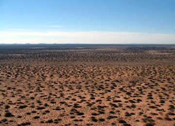
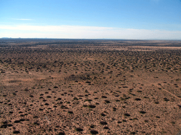
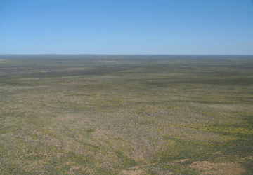
March 3, 2005 VHN-BPG Van Horn, Texas to Big Spring, Texas It's cold but clear this morning and the wind from yesterday is still blowing a brisk 15 knots. Not a cloud in the sky here but a call to flight service brings the surprising news that from Midland Texas eastward it is all instrument flying conditions with ceilings at 100' to 1,000' and visibilities between 1 mile and only a 1/4 mile. At least I'll be able to move on 150 miles then decide if I can continue. Dee and I agree to talk by phone before passing Midland. I preflight the aircraft then return to the motorhome to warm up from the biting wind. I debate putting the doors on the gyroplane to keep from freezing but it flies so much better without them especially in the gusty winds. Landing in cross winds is much more difficult with the doors on so I opt for safety over comfort and put on plenty of warm clothes. The first part of the trip is over flat West Texas but then I climb up to pass a gently rising ridge after which the land is lower. I go up to 5,000' and can finally see I am high enough to clear the ridge comfortably but as I near the top the terrain gets very rocky and broken. It is probably the roughest ground I have traversed so far and losing an engine here would be dangerous so I breathe a big sigh of relief when I'm past this area. I had planed to fly to Monahans but as I near Pecos my bladder tells me it's time for a break so I pull the power and drop down for a smooth landing. I'm greeted by Isabelle who runs the airport guiding me into a parking spot on the nearly empty ramp. She sees how I'm dressed and immediately offers hot coffee. I tell her I'm not a coffee drinker and moments later she has brewed up some apple cider which warms me nicely. Chatting with her is delightful as she tells me about her childhood in Kenya before coming to the US to continue her flying career. From here it is only a few miles to the Pecos river made famous by "Hanging Judge Roy Bean" law west of the Pecos. I remember the true stories and the movie they spawned starring Paul Newman. For the next section I climb up to about 1,500 feet above ground to be sure of avoiding the dozens and dozens of radio towers that reach up as much as 800 or more feet. The towers, all marked on my GPS screen, are a bit scary nevertheless. I try to get an updated weather report about the area that was clouded over before but am unable to raise flight service. In a few more minutes I'll enter the airspace reserved for Midland Odessa airport so I abandon the quest for weather and call Midland to request clearance to fly through their airspace. They are not very busy and let me continue on my way with no diversions. By now I can see at least 30 miles ahead and all looks clear - my destination is not far off now. Earlier today I had noticed a brief short in my noise canceling headset and now it seems to be totally non functional. These special headsets do a fantastic job of quieting my noisy gyro and now without it I realize what a huge difference they make. After 3 hours I have a splitting headache. The pain in my head magnifies my other minor discomforts and I'll be glad to get on the ground after 3.8 hours aloft today.
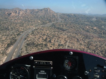
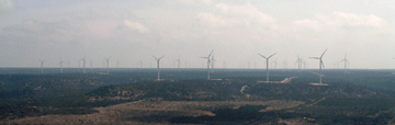
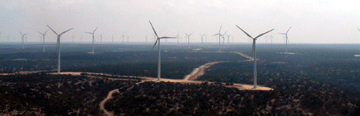
March 4, 2005 BPG-ABI Big Spring, Texas to Abilene, Texas The day dawns clear and a bit warmer with blue skies and a 10 knot of wind from the West. I'm outside at 8 a.m. in shirtsleeves getting the motorhome ready for travel. At 8:45 I head back outside to fuel the gyro- it seems a bit cooler than it was earlier but maybe it's my imagination and the sky is still clear and blue. Then as I'm lugging the gas cans across the ramp I feel a distinct cold wind on my back. Putting down the cans and looking over my shoulder I see a fog bank rolling my way. In seconds the visibility has gone from 30 miles to 1/4 mile. The weather station inside the airport reports a ceiling of 100' and visibility of less than 1/4 mile so it's time to have another cup of tea and hope it warms up in a few hours. If the temperature climbs 8-10 degrees that should provide enough of a temperature/dewpoint spread to lift the clouds. I wait a bit after the clouds lift as they are moving in my direction and I don't want to leave here only to fly into them again 20 miles down the way. It is a long taxi to the runway and the engine is well warmed up by the time I lift off into 12 knots of wind straight down the runway from the North. Despite my waiting half an hour I've caught up to the clouds and cold air again. With the doors off in 50 degree temperatures and a 60 mile an hour speed the heat is sucked from my body. I'm dressed warmly but only have on a baseball cap. After delaying as long as I can I finally decide I have to get my ski hat on but doing so is a bit of a juggling act. In a gyro like mine with the propeller behind me there is an ever-present danger of losing something out of the cockpit and the wind pulling it right into the propeller. Even something as small as the pencil I use to write down instructions from the tower could ruin a propeller blade with possible disastrous consequences. Each move must be thought out in advance. I fumble in my pack to make sure my hat is accessible near the top, then steering with my knees I pull off my headsets and baseball cap and yank the pile ski hat out and cram it down around my ears. Instantly I'm warmer but I still have to juggle pulling my headsets back on which takes both hands. While I'm doing that a gust yaws the gyro and air coming in sideways through the doors catches inside my baseball cap and tries to yank it from my hands. I grab the stick and straighten the craft with one hand while holding on tight to the hat with the other hand and trying to cram it into my open pack on the seat next to me. At my low altitude my radio is unable to reach a flight service station for a weather update. Abilene may be fogged in so I check my map and see that Sweetwater is half way there and only a few miles off my route. I split the difference between my direct course and a route to Sweetwater figuring I can divert there if the clouds drop down too low. Fortunately the clouds stay about 2,500 above the ground and I continue on my way towards an area where the chart shows dozens of towers. Since I fly quite close to the ground seeing towers and power lines are my biggest worries and I ponder what all these could be as usually radio towers are widely spaced. Soon I see dozens of white pillars sticking up into the sky. Well that is one worry aside as there is no problem spotting these. As I get closer I see they are all windmills with huge slowly turning blades. For the past two days I've been plagued by gusty winds and also seen several areas on the chart with these strange clusters of towers, now it all makes sense. So far today I have not taken any pictures as it's been too cold to motivate myself to grab the camera. But the windmills look great so I decide to fly close and take a few shots. The windmills are on the edge of a cliff, placed there specifically to get the increase in wind caused by the cliff face so I prepare myself for some strong gusts. In a regular plane I would never fly so close to the cliff or the windmills but with the maneuverability of the gyro it's easy and the fun factor is terrific. My spirits rise now and I forget the cold and cloudy conditions enjoying myself again and reminding myself how lucky I am to be able to do this trip. In a few minutes I'm on the radio with the approach controller at my original destination of Abilene. He clears me on my way with only minor detours before handing me off to the tower controller who tells me I can land on the runway or the taxiway. I touchdown on the taxiway with a smooth landing and follow his instructions to taxi behind the military T-37 jet trainers. On the ramp I trade comments with the dozen Air Force guys who have just flown in on a training mission. We admire each others rides while one of them explains to me that he is in the Tunisian Air Force on an exchange to the U.S. He has 200 hours so far and will graduate to flying F5's for his own country. Unlike private pilots who learn in underpowered Cessna 152's most military pilots start their training in these awesome jets that fly at 250 knots!
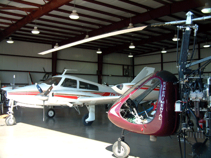
March 6, 2005 ABI- ETN- FWS Abilene, Texas to Fort Worth, Texas Another foggy morning and flight service reports IMC (Instrument Meteorological Conditions) all along my route. IMC means you can not see the ground and are flying in clouds depending on your flight instruments to keep right side up and on course. To fly this way you need an instrument rating and a suitably equipped aircraft. I have the rating but my gyroplane is only set up for VMC (visual meteorological conditions) meaning I need to see the ground and the horizon and stay out of clouds. The weather should improve along my route by noon but rain showers are predicted by 2 p.m. so I will have a small window that should work. I'm off by 12:15 into a headwind that reduces my groundspeed to only 52 knots. I had planned on flying direct to Fort Worth but I decide with the wind slowing me down a fuel stop would be prudent so I alter course and touch down at Eastland. The airport is deserted though there is a credit card operated fuel pump so I fill up and take-off again. Flying under this grey haze does not have the allure of the 60 miles visibility and blue yonder skies I am used to in the Western U.S. Shortly after take-off from Eastland my GPS flashes a low battery indicator. Not good. I take a quick bearing to my destination and note the distance then shut off the GPS to save whatever power is left. 42 miles away on a compass course of 79 degrees. Hmmm. I now realize the switch providing electricity from my alternator has failed and the GPS has been running on its internal batteries which are now drained. Most aircraft have several other systems for navigation but my gyro has none of these. If I had been following the interstate I could navigate by that and hopefully find the airport but I am over featureless plains leading to Ft. Worth and when I get there I will have no idea of where I am over the unfamiliar city. I fly on being very careful to maintain course by my constantly vibrating compass. I almost always fly by the GPS readout and so following the compass is a new experience. If I fly right on course for 42 miles I won't know whether to turn left or right to find the airport so rather than fly the course of 79 degrees I make sure to fly about 75 degrees. There is also a wind from the South so by purposefully flying a bit north of my course and letting the wind push me north too I will certainly know that after 42 miles I should look to the South to see the airport. As I ponder my situation I'm suddenly very happy that I made that fuel stop. At least I won't be lost over Ft. Worth and out of gas too! I realize how dependent I am on the GPS. With minimal instrumentation and a small fuel tank it's important to consider what my other options are. I decide to fly the compass course and guestimated distance until I am 5 miles out from the airport then flip the GPS on again and see if it will last long enough to get a position fix and tell me where I am in relation to the airport. The visibility is only about 5 miles but the weather is holding so I continue marking off the minutes and flying by the compass. I cross a river and note where it is on my chart and my time as I cross it. I don't have an exact fix but it agrees with my timing. Then out of the fog I see a huge tower off to my right- I'm flying at about 1000' above the ground and it looks almost as tall. That MUST be on the sectional chart. Sure enough there it is an 821' foot tower just a few miles from the airport. I call the airport controller and get clearance to proceed even though I don't yet know exactly where the airport is. As I fly the last few miles I try the GPS again and it comes on and confirms my position - no worries now. I smile inside that I've dealt with the situation so well. I even have a greaser landing and the flight comes to a perfect close. On the ramp the two young line guys have a million questions about the gyro which I cheerfully answer. This is a busy commercial airport and they've parked me next to a Citation Jet and a million dollar Malibu Meridien. As I pack up my gear the pilots of these two beauties come over to ogle my tiny gyro and ask how it flies. March 7, 2005 FWS- 7F3- TRL Fort Worth, Spinks to Caddo Mills to Terrell, Texas Another foggy morning of instrument conditions so we wait until noon for it to lift. As I get ready to launch a gentleman comes over and invites me to join he and his colleagues for lunch. He is from Ball Corporation and is piloting the beautiful Challenger Jet on the ramp next to me. When the line guys told him about our flight he was interested in hearing more but unfortunately I have a lunch date at Caddo Mills with Doug and John from Air Command Gyros. My departure from FWS is the scariest take-off I've ever had. There is a cross-wind of nearly 90 degrees gusting from 11 to 16 knots and I find myself skidding sideways across the runway before I get to flying speed. I handle the situation poorly and I'm very lucky to get off with just a scare. Tipping over and damaging my rotor blades were just a hairsbreadth away. As I fly to Caddo Mills the gusts increase throwing the gyro sideways a number of times requiring constant attention to the flying. I monitor the weather broadcasts of nearby airports and hear reports of west winds gusting between 16 and 24 knots. Those are ground reports and here 1,000 above the ground (AGL) it is nearing 30 knots. Fortunately it is a tailwind for me. For an experiment I turn into the wind and reduce the throttle. A gyro won't hover like a helicopter but into this 30 knot headwind I almost manage it reducing my speed over the ground to maybe 10 mph. Caddo Mills has 3 runways so I can land directly into the wind and it is almost like a helicopter landing as I drop nearly straight down onto the runway. Doug and John give me a tour of their operation and offer to help with anything I need on my gyro. Besides gyros they have all sorts of interesting projects from gliders to military target drones. Doug enjoys seeing my gyro and excitedly shows me the latest improvements they are making to the Air Command line up. I'm not anxious to tackle more of this wind but it shows no signs of letting up so I finally decide to launch. It takes me nearly 2/3 power to stay still on the runway without being pushed backwards as I spin my blades up. I'm off the runway in about 100' and I turn south for Terrell airport just 20 miles south where Dee is waiting. On the ramp the wind is rocking the gyro all over the place and the folks at the FBO kindly make room inside the hangar for my gyro. At Terrell were joined by Kerry Cartier who is active in the PRA (Personal Rotorcraft Association), the main organization representing gyroplanes. Kerry gives us a tour of his great pad which is just what every gyro nut wants. A cool hangar on the edge of a private airstrip and upstairs from the hangar is a wonderful apartment. After the tour Kerry takes us out for a great Mexican dinner.
March 8, 2005 TRL- 4O4-TXK-3F4-ASL A beautiful morning with not a cloud in sight and calm winds. I spend some time doing a few minor maintenance jobs then takeoff into the crystal blue sky. At 200' I roll into a turn and fly over the FBO waving to the guys below. It's two cold hours to my destination but the green fields of East Texas are beautiful in the early morning sunshine. I swoop in for a gentle touchdown at Idabel, Oklahoma. The airport is new but mostly deserted. I spend some time chatting with an American Airlines pilot who is on a day off jaunt in his Beechcraft Bonanza. After topping up the gas tank and running laps to warm up I take-off again for Arkansas. This leg of the trip is a over lots of piney woods and swamps. I zig zag as much as I can to stay over open fields or roads in case I have to make an emergency landing. By the time I reach Texarkana the afternoon winds have picked up. The controller in the tower is unfamiliar with gyroplanes and has to ask me if I land on skids or wheels and do I land on the ramp or need the runway? I explain that I have wheels and need a bit of runway to land, so he clears me in. When I'm about 3 feet off the ground I get hit by a big gust which yaws me sideways and my reaction is instantaneous as I cram in full power and declare that I am making a go around. I could have tried to save the landing but in this situation aborting the landing is by far the safest move. As I climb up to about 50 feet the tower asks me my intentions and I tell him I'd like to land on the taxiway in front of me which he clears me to do. In a moment I roll into a turn and softly set the machine down on the taxiway which being perpendicular to the runway is facing directly into the wind. From aborted landing to actual landing is only maybe 20 seconds. In Texarkana a local man comes out to see the gyro and tell me about the restored Piper Cub he flies. He explains that he's retired and each day after he finishes the "honey do" list he hangs out at the airport. On the wall inside he shows me a picture of his perfect little yellow cub with the Governor or Arkansas standing next to it. The aircraft had been his father's and his dad had taught him to fly it in 1973. After a career flying helicopters and planes in the military including dozens of missions over Iraq in the first Gulf war he returned home and retired. When his father passed away he and his brother decided that in their father's memory they should restore the old Piper Cub that had been sitting derelict in the barn for 30 years. The restoration was beautiful I and I have no doubt that each time he lifts that bright yellow beauty into the sky his Dad is in back riding along. From Texarkana, Arkansas I drop down for a touch and go in Vivian, Louisiana before flying back into Texas to meet Dee at Marshall. I've touched down in four States today and flown for 4.4 hours.
|
||||||||||||||||||||||||||||||||||||||||||||||||||||||||||||||||||||||||||||||||||||||||||||||||||||||||||


Home | Log 1- Arizona, New Mexico, Texas | Log -2 Louisiana | Log 3- Florida | Emergency Landing | Log 5- Georgia, So. Carolina | Log 6- North Carolina | Log-7 TN, KY, WVA | Log- 8 Virginia | Log-9 MD,PA,DE, NJ | Log 10- New York | Log 11 CN, RI, MA | Log 12 NH, ME, VT | Log 13- NY, OH, MI | Log 14- Indiana | Log 15- IL, WI, MN | Log 16- IA, KS, NE | Log 17- CO, WY & Dakotas | Log 18- Montana | Log 19- Idaho,Wash, Oregon | Log 20- California | Log 21- Nevada, Utah
This site was last updated 06/12/06